ViewRanger publishes selection of 2011 Isle of Wight Walking Festival routes

posted by cw on Thursday, April 28, 2011


With the 2011 Isle of Wight Walking Festival (7th-22nd May), just over a week away, we have today published a selection of Festival walks available to download onto your smartphone using the ViewRanger app.

Through our “Partner” association with the 2011 IOW Walking Festival, we are delighted that the organisers have agreed that each of the routes will be free to install for the duration of the event.

A total of 15 walking routes are available these include the 6 stage trail of the Island Coastal Path and a selection of other trails between 5 and 15 miles in duration.

Each downloadable route comes complete with mapped trail, navigation and historical information as well as photos of points along the way.

ViewRanger will be present at the opening day event in Seaview, so if you’re going along do come and say hello.

View the Festival routes on the Isle of Wight Walking Fetival page at the ViewRanger online community website or search for "IOW" from the app on your phone.

Labels: , , , ,

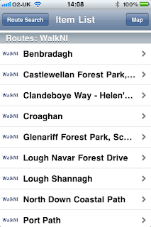
Northern Ireland Topo Maps and WalkNI Routes Now Available

posted by cw on Thursday, April 21, 2011

We're really pleased to release Northern Ireland mapping and route content into the ViewRanger content library today.


Topo Maps

We've worked with Ordnance Survey Northern Ireland to bring both 1:50,000 Discoverer maps and 1:25,000 scale Activity maps to ViewRanger.

The 1:50,000 maps are available to download direct to the handset as 10km x 10km map tiles; or as an "all" Northern Ireland region download (available in-app or through our webshop). These tiles work seamlessly with our existing Ordnance Survey Ireland maps - allowing a seamless map across the whole island.

The 1:25,000 activity maps are available to download as map regions in-app and through our webshop. Six regions are available: Causeway Coast, Glens of Antrim, Mournes, Lough Erne, Strangford Lough, and Sperrins. The digital maps, which cost just £7.99 each, exactly mirror the paper Activity Maps published by OSNI.

WalkNI Quality Walking Routes

To complement the OSNI mapping, we are working with WalkNI and CycleNI, in association with Northern Ireland Tourism Board, to bring you the best walking and cycling routes across Northern Ireland.

Today we've released 19 Quality medium length walks. These are available to browse and download through the ViewRanger app, and can be browsed on the new ViewRanger online community and trip planning website.

More to come...

With Northern Ireland Tourism Board we are working to bring you the best content to explore this country - so look out for more great routes and information to be published over the next few weeks.

ViewRanger adds 1,300 Walkhighlands trails to its database of downloadable leisure routes

posted by cw on Thursday, April 21, 2011


It's a very busy content publishing day for the ViewRanger team, again, today.

We are delighted to announce the addition of 1,300 guided walking routes for Scotland following the conclusion of a publishing agreement with the popular walking routes website Walkhighlands. These routes are available immediately on Apple, Android, and Symbian devices.

The addition of Walkhighlands to the ViewRanger publishing roster makes our App probably the UK’s most comprehensive source of expert planned guided walking trails and cycling rides offering access to almost 10,000 routes nationally. Every expert guided route can be installed onto your smartphone with just a few taps providing a mapped path and navigation.

Embedded within each of the routes, you can access a wealth of local expertise, for instance many of the Walkhighlands routes even feature audio clips giving the correct pronunciation for place names.

The routes from Walkhighlands offer walks for all tastes from challenging trails up every Munro to short woodland or even urban walks. An important part of its mission is to help the small, local tourism businesses so vital to Scotland's rural economy.

All registered ViewRanger customers can try a Walkhighlands route for free as these are included in the free routes promotion running now until 2nd May. You can also view the Walkhighlands routes through the web at their profile page at My.ViewRanger.com

Going Cycling? More Nick Cotton Rides Now Available

posted by cw on Wednesday, April 20, 2011

We've just added a further 73 brilliant route guides from Nick Cotton Rides to the ViewRanger trails and routes content library.

Featuring routes from the Cotswolds and from Dorset, this latest collection joins the 200 existing Nick Cotton Rides already available.

These routes, like all ViewRanger routes, are available to download in the ViewRanger app for Apple, Android and Symbian smartphones and tablets. They are also available to discover and browse within the new ViewRanger online community and trip planning website.

Find these routes at the Nick Cotton Rides profile page within the my.viewranger online community or search within the ViewRanger app on your mobile device.

The Nick Cotton Rides are published in association with cycle-routes.com

Android beta updated to 1.5.5

posted by Mike Brocklehurst on Friday, April 15, 2011

The Android beta has been updated to v1.5.5.

The main change is the addition of Synchronising with the new My.ViewRanger web site - this allows you to upload and download routes, and to upload tracks.

A few problems have been fixed too. The release notes have more details.

The beta is available from www.viewranger.com/vranbeta. Note the beta is not available through the Market, and if you switch from a Market version you'll need to get a key from us.

Get Free Routes To Celebrate My.ViewRanger Community Site

posted by cw on Wednesday, April 13, 2011


If you’re thinking of getting out for a walk or cycle over the upcoming public holidays, why not let your phone guide you? We are providing a free cycling or walking route each of those days – that’s four free routes to download from our massive library of premium, expert authored, guided routes.

The free routes are to celebrate the launch of our brand new online community & route planner “My.ViewRanger.com”. The new website works alongside our app and will make it even easier for you to plan, find and share trails using the big screen of your pc or laptop.

Choose from route publishers including WalkingWorld, Cumbria Tourism, Cordee and The AA, CityCycleGuides and Nick Cotton Rides.

My.ViewRanger.com is free to use and all ViewRanger customers can log-in using their existing ViewRanger mobile account details. Once logged in, you can link the service to your mobile device and use it to create your own routes or browse and choose from the massive database of published routes. The website is also accessible to non-customers, so it can be used to invite friends to participate in activities, by sharing a link by e-mail, Facebook or Twitter.

The promotion runs over the period Sunday 17th April to Monday 2nd May covering the Easter, Royal Wedding and early Spring 2011 bank holidays: Good Friday April 22, Easter Monday April 25, Royal Wedding April 29, May Day May 2.

The free offer covers all standard routes (excl Hadrian’s wall Video & Guides incl mapping) from ViewRanger for all registered customers (includes those using the 15day free trial over the period). The first 4 paid routes from any publisher will be delivered at no charge. Subsequent routes during the period will be charged as normal. Free routes (eg Trail Magazine routes) do not count against the 4 free paid routes. A customer with a zero credit balance can benefit from the 4 free routes providing that they are registered. Customers who do not download all 4 routes before 2nd May will not be able to access the offer after this date. The normal value of routes varies between about 50p to £2.00.

ViewRanger for Android Beta - Trip View

posted by Mike Brocklehurst on Friday, April 01, 2011

A new beta release of ViewRanger for Android is available. It adds the new Trip View. You can configure the Trip View to show a number of different statistics, such as speed, distance, time, compass, and navigation.

The beta can be installed by using your Android phone's web browser to visit www.viewranger.com/vranbeta. (Sorry, betas are not available through the Market, so if you use the Market version you need to wait for the end of the beta.)

It also addresses a frustration some users have had with the BuddyBeacon. Now, if you manually send a BuddyBeacon this will also send the historic data points if there are data points that haven't been sent yet. Historic data points are the BuddyBeacon messages that the device was unable to send at the time because you were temporarily out of mobile network coverage.