Beta updated

posted by Mike Brocklehurst on Friday, March 30, 2007

The beta has been updated to version 2.3.4. There have been a number of small changes and fixes, which are detailed in the revised release notes on the beta download page. If you need a link to the beta download page, please email support@viewranger.com.

Most notably:
  • Problems saving and deleting Trip profiles have been fixed.
  • The occasional cookie error when using the server has been solved.
  • The shortcut to show the Trip view now toggles between the Trip view and the map view. (The default shortcut is 7, but you may need to choose this in Settings > UI.)
  • The image and details view now finds images if they have been moved, and displays a generic icon while they are loading. The tag has been extended to allow additional images to be associated with a POI.
  • When set to use a UTM zone with no maps, the "No maps here" message is no longer displayed on screen.

Thank you to everyone who has tried the beta, and especially to those who have sent feedback!

New beta release

posted by Mike Brocklehurst on Thursday, March 15, 2007

A new beta release of ViewRanger is now available. If you would like to try it please email support@viewranger.com.


The main new features include:

Trip view

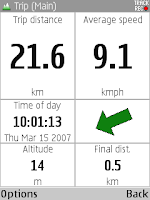
The trip view displays a range of statistics about your current journey. You can configure which statistics are shown and can choose from several different screen layouts. The statistics include values such as distance, speed, average speed, time moving, estimated time of arrival, altitude and pace.

You can save different combinations and layouts as profiles, and step through the profiles with the arrow keys.


Track and route graphs

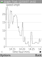
For a track you can display graphs of speed, altitude, GPS altitude and distance against time. You can display these individually or superimposed.

For a route you can display a graph of altitude against distance.


Buddy Beacons

You can send your location to the ViewRanger server. If you give friends your details, they can see your location either using their own copy of ViewRanger or using a web page. You can send your location once, or can send it repeatedly.


International support

The international UTM coordinate system is now supported. Tracks can be recorded and POIs can be created worldwide.


Internal GPS

The GPS built-in to the new N95, E90 and 6110 phones is supported.


Routes, Tracks, GPS and GPX

Tracks store the GPS altitude, which can be exported to GPX files.

Tracks are split into segments when the GPS is disconnected then reconnected, or when track recording is switched off and back on.

Selective GPX import and export – you can import just the routes from a GPX file, ignoring the tracks and single points, or can choose to just export tracks.

On 3rd edition phones routes can be made partially transparent.


If you have any questions or would like to use the beta please contact support@viewranger.com or phone 020 7193 7233.

Labels: , , , , , , , , ,