New beta release
posted by Mike Brocklehurst on Thursday, March 15, 2007A new beta release of ViewRanger is now available. If you would like to try it please email support@viewranger.com.
The main new features include:
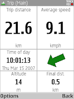
Trip view

The trip view displays a range of statistics about your current journey. You can configure which statistics are shown and can choose from several different screen layouts. The statistics include values such as distance, speed, average speed, time moving, estimated time of arrival, altitude and pace.
You can save different combinations and layouts as profiles, and step through the profiles with the arrow keys.
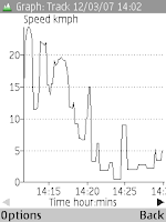
Track and route graphs

For a track you can display graphs of speed, altitude, GPS altitude and distance against time. You can display these individually or superimposed.
For a route you can display a graph of altitude against distance.
Buddy Beacons
You can send your location to the ViewRanger server. If you give friends your details, they can see your location either using their own copy of ViewRanger or using a web page. You can send your location once, or can send it repeatedly.
International support
The international UTM coordinate system is now supported. Tracks can be recorded and POIs can be created worldwide.
Internal GPS
The GPS built-in to the new N95, E90 and 6110 phones is supported.
Routes, Tracks, GPS and GPX
Tracks store the GPS altitude, which can be exported to GPX files.
Tracks are split into segments when the GPS is disconnected then reconnected, or when track recording is switched off and back on.
Selective GPX import and export – you can import just the routes from a GPX file, ignoring the tracks and single points, or can choose to just export tracks.
On 3rd edition phones routes can be made partially transparent.
If you have any questions or would like to use the beta please contact support@viewranger.com or phone 020 7193 7233.
Labels: 6110, beta, buddy beacon, E90, graph, N95, profile, track, trip, UTM

4 Comments:
Oh now the hint of foreign maps has me interested...
Going to the alps again in June - want a foreign map beta tester??
Well got out last weekend and used it for the first time in very very bad weather on Snowdon. Very quick to give my position. I was realy happy with Vewranger and I am not very good with finding my way round complicated programs etc. I am upgrading my phone when the 18 month contract is up around July and will keep my eyes open for N95.
foreign maps eh?
Whistler would be nice, i'm there for a month in June
Just thought that I'd pass on a problem that I am having with the beta release that you made available mid March. On my Nokia 5500sport when I clear the screen of all overlays and then choose the overlay that I want to view, I can't see it at all, I know that the data is there because I can see it in the tracks folder and I can convert to .GPX for memory map.
I've also had more crashes with this version, I am however now going to try the latest update so this may not happen!
Post a Comment
Subscribe to Post Comments [Atom]
<< Home